Weather constantly changes, with weather systems forming and dying;
they move and affect many areas of the country in succession. To keep track
of the location and movement of these systems, we must measure the weather
elements simultaneously and make maps and charts that reflect the weather
conditions at a given time. Furthermore, because of the size of these systems,
observers around the world have to coordinate their efforts in the enterprise.
At what time should we make
our observations? What do we even mean by the time anywhere in the
world? The current weather maps that you will use in this course are identified
in "Z time".
CIVIL TIME ZONES
For centuries, humans measured their activities by the daily motions of the sun. Local noon was a convenient reference, marking the time when the sun would be overhead locally. As a result, locations even several miles displaced in the east-west direction could have different local times. With more rapid long distance transportation and communication made available by the railroads and telegraphy after the American Civil War, travel east or west meant that a person's local time kept constantly changing. To reduce the large number of locally observed times, the railroad companies pushed for the simplified standardized time keeping scheme we currently know. As a result, civil time zones were initially instituted in the U.S. and Canada in 1883 to standardize time keeping. The concept of international time zones was officially adopted in November 1884 at the International Meridian Conference in Washington DC. Because The Old Royal Observatory in Greenwich, England had instituted the best early astronomical time determinations, the meridian of longitude passing through this observatory became the Prime Meridian and serves as the world-wide standard for time keeping.
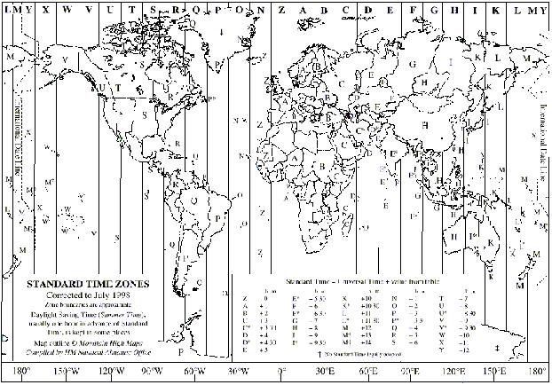
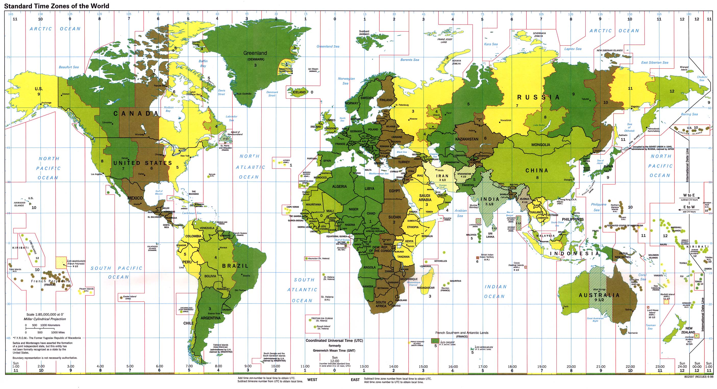
The Earth rotates in a counterclockwise (west to east) direction at a rate of 360° of longitude in 24 hours; in one hour, the Earth rotates through 15° of longitude. Ideally, then, there should be 24 major civil time zones of equal width each of which representing one hour of time. The Prime Meridian serves as the central meridian for the initial time zone. Every 15th degree of longitude from the Prime Meridian is a central meridian for a time zone (15°, 30°, 45°, 60°, 75°, 90°, 105°, 120°, 135°, 150°, 165° and 180° east and west from the Prime Meridian). Each time zone theoretically extends 7.5° to the east and west of its central meridian, with some variation for political reasons. Time zones to the east of the Prime Meridian experience later time than that at the Prime Meridian, whereas time zones to the west of the Prime Meridian experiences earlier time than at the Prime Meridian.
If you were located in the U.S. Eastern Standard Time Zone, you would
be near 75°W longitude (5 times 15). At any place in this zone,
you would be 5 hours different from time in Greenwich, England, UK.
With the Earth rotating eastward, Greenwich is ahead of EST then by 5 hours.
For example, noon in Greenwich (1200) is only 7 AM EST. To reduce
confusion, all times should be expressed in the 24 hour time format, such
that, 8:45 A.M. = 0845 and 1:15 P.M. = 1315. For a map of the world
time zones on the U.S. Naval Observatory web site, click onto:
http://aa.usno.navy.mil/AA/faq/docs/world_tzones.html
For a larger map: Time Zone Map
METEOROLOGICAL TIME KEEPING
Since the collection and exchange of weather information are of international concern, use of a single worldwide time system is needed so all weather observers around the world can take measurements at the same time, providing a "snapshot" of the weather. The times for essentially all meteorological reports are given according to the Universal Time Coordinated System (UTC), the current name for Greenwich Mean Time (GMT). Often, a single letter, Z, phonetically called "Zulu" is used because this letter is used to identify the Greenwich time zone (centered on the Greenwich Prime Meridian). The time given on all weather maps is given as Z-time, the time it is at the Prime Meridian.
By international agreement, surface weather observation times are minimally 0000 Z, 0600 Z, 1200 Z and 1800 Z, with upper air measurements at 0000 Z and 1200 Z each day. In the U.S., surface observations are taken hourly (at the top of the hour). Radar summary charts are also hourly at 35 minutes past the hour. Fronts are analyzed on maps every three hours, 0000 Z, 0300 Z, and so forth.
You can use the table below to convert Z or GMT to your local U.S. time.
The numbers in the table represent the number of hours we are earlier
than the time at the Prime Meridian.
|
|
|
|
|
|
|
|
|
|
|
|
|
|
|
|
|
|
|
|
|
|
|
|
|
|
|
|
Modifications of the boundaries between time zones have been made to accommodate political boundaries in the various countries. Some countries adhere to a local civil time that may differ by one half hour from that of the central meridian. For the precise location of the four time zones in the continental United States, consult a recent atlas or almanac. While most of the United States observes Daylight Saving Time during the summer (April through October), UTC remains fixed and does not adhere to a "summer schedule". Therefore, you will have to adjust the time by one hour during summer. As an example, during the summer, the residents in the U.S. Eastern Time zone will lag Greenwich by only 4 hours, with 0800 EDT = 0700 EST = 1200 Z.
THE TIME IS CURRENTLY ...
Suppose that you would like to know the current time as maintained by the Master Clock at the U.S. Naval Observatory in Washington, DC. So get your clocks or watches ready and then access the current time from the Time Service Department at http://tycho.usno.navy.mil/.